Illustrated Route Description: From Chiang Mai on Highway #118 to Baan Sammi — English Detailed Version, with Brief Notes in Thai.


■ The following section numbering (1–22) corresponds to the landmark numbering in both maps: the Generalized Offline Map and the Accurate Offline Map.
■ Each of the two maps in conjunction with the route described and illustrated herein is helpful for orientation and navigation, especially if you are driving to Baan Sammi by car or motorbike yourself, or, if you are the passenger and the driver needs your help in navigation.
■ If you do not drive yourself, but use public transportation (song-thaeo and saleng), it is advisable to also read the blog Public and Private Transportation in Chiang Mai.
■ If you use semi-public transportation (Grab, Bolt), rest assured that the driver will find the way himself.
1. Starting point: From Intersection San Dek (สี่แยกศาลเด็ก), where Super Highway #11 underpasses Highway #118 (the latter also called Chiang Mai – Doi Saket – Chiang Rai Road, ถ. เชียงใหม่ – ดอยสะเก็ด – เชียงราย), → Google Street View.
► Location on Google Maps — สถานที่ตั้งบน Google Maps.
2. Take Highway #118 towards Doi Saket or Chiang Rai (ถ. เชียงใหม่ – ดอยสะเก็ด – เชียงราย). Keep on this highway for several kilometers. — ไปทางดอยสะเก็ด — You will cross two intersections with traffic lights and overpass a third, an interchange without traffic lights:
The first intersection after 1.1 km (0.7 mi) (→ Google Street View) overpasses Middle Ring Road #3029.
The second intersection, a T-section with Road #1367, follows after 0.2 km (0.1 mi).
The third intersection, an interchange, follows after 2.5 km (1.6 mi) and Highway #118 overpasses Highway #121 (Outer Ring Road).
3. After 4.2 km (2.6 mi) from the interchange, you will reach Ban Bo Hin, a village that is easily recognized by its pedestrian bridge over the highway.
4. After passing the gasoline stations, you will pass on the left a village (Horizon Village) delimited by a low wall and with the Horizon Tower, which is not easy to see because it is hidden by trees, and the tower is with an advertising panel in Thai and Roman script; the main text reads ทวีชล (Thawichon) and Horizon Village & Resort.
5. After 100 meters (300 ft), you will pass the entrance of HORIZON VILLAGE & RESORT (โรงแรม ฮอไรซัน วิลเลจ แอนด์ รีสอร์ท).
6. Continue, and 200 meters (0.1 mi) ahead, you will pass twin road signs, บ. น้ำแพร่ (Ban Nam Phrae) and บ. ป่าดู่ (Ban Pa Du) (in black Thai script on a white ground, the signs pointing to the right), and immediately thereafter you will cross a bridge over a small canal, คลองน้ำแพร่ (Klong Nam Phrae).
Ban Nam Phrae is a village adjacent to the right (eastern) side of the highway next to that bridge. There is the Intersection Ban Nam Phrae where the country road underpasses the highway. If you don't know yet about this complex and confusing intersection with its two rather narrow underpasses parallel to Klong Nam Phrae, in no way should you take these underpasses when driving a car! It is strongly recommended to take the next U-turn of the highway when driving a car, but if you are an experienced motorcyclist, you may take that underpass instead of the U-turn, and, above all, if you are a bicyclist or pedestrian, taking the underpass carefully would be your best option.
7. There is a U-turn on the highway just 500 meters (0.3 mi) from the bridge at Ban Nam Phrae. This is the first U-turn after Horizon. Take this U-turn. — ที่กลับรถแรก
8. So, after the U-turn, you are taking the highway in the opposite direction (towards Chiang Mai), but you need to exit the highway after only 500 meters (0.3 mi). Along these 500 meters, you will pass two road signs (the signs point to the left). The first road sign, บ. น้ำแพร่ (Ban Nam Phrae), was recently removed and may be reinstalled later. The second traffic sign, บ. ป่าดู่ (Ban Pa Du), is still present.
9. You have reached EXIT 'BAN NAM PHRAE' of Highway #118, where this exit becomes a country road on the left just before the bridge. Leave the highway here (turn left) and continue on the country road.
10. Once you turn onto this country road, you will pass the village, Ban Nam Phrae, and 400 meters (0.3 mi) from the exit, the monastery, Wat Nam Phrae (วัดน้ำแพร่), will be on your right. Continue towards the next village, Ban Pa Du. — ทางออกถนนไหญ่ที่ บ. น้ำแพร่ไป บ. ป่าดู่
11. Exactly 1.5 km (0.9 mi) from the Ban Nam Phrae exit, or 350 meters (0.2 mi) before the village center of Ban Pa Du, the country road comes to a sharp left curve with a T-junction of a subordinate road. Don't go straight onto the subordinate road! Follow the country road in the left direction!
12. You will pass through the village center of Ban Pa Du. Only 180 meters (0.1 mi) after the village center, there is a junction, where the difficult-to-see main route turns right towards the village Ban Pa Lan, while the subordinate road goes straight towards Ban Pa Tio, and the left subordinate road is a new dead-end street.
13. If you have followed the (main) country road by turning right, just 150 meters (500 ft) from the junction, you will pass the monastery of Ban Pa Du which is on your right: WAT SI PRA DU.
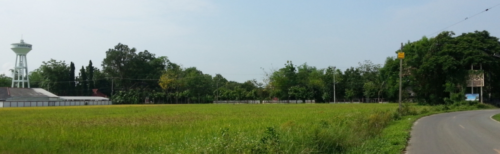
14. A few hundred meters from this monastery, you will approach the next village, Ban Pa Lan (บ. ป่าลาน), marked by a village sign in black Thai script on a white background (the sign is currently defunct). The village consists of loosely scattered houses, and when you pass the first group of houses in this village, you will see a tall white concrete water tower beyond a rice field on your left.
15. Further ahead, and only 850 meters (0.5 mi) from the monastery of Ban Pa Du, you will see a small cremation area with a tall cremation tower on the left side of the road. The view of the tower could be obscured by trees and thus overlooked. Slow down!
16. Just at the end of this cremation area, there is a T-junction, where a narrow, subordinate road divides from the country road. Turn left here. — เลี้ยวซ้ายสามแยกทางไปวัดป่าลาน
17. Only 140 meters (460 ft) from the junction, you will pass the monastery of Ban Pa Lan (วัดป่าลาน), which is on your right and is hidden by a tall Bodhi tree: WAT PA LAN.
18. Only a few meters after the monastery, you will reach a junction where the main route branches off to the left.
19. Halfway to the village, Ban Pa Yang Poi, you will see a large, light gray new building (a vehicle body repair and paint shop) on the left.
20. Follow the country road for a few hundred meters, and then you will reach the village, Ban Pa Yang Poi, previously hidden by trees (as shown in the photo), but most were cut in 2025.
Just where the trees previously obscured the view, the country road makes a sharp right turn, with a side road joining from the left. Drive slowly; this T-junction is dangerous, and turn left onto the minor road!
21. Then go straight and after a few meters, you will see a second T-junction, which you will pass straight ahead, but drive more slowly! — เลี้ยวซ้ายสามแยก บ. ป่ายางปอย หนึ่ง้อยเมตรถึง บ้านแซมมี อยู่ข้างขวา
22. On the right side, along the road and ditch, you will see the typical wooden fence of the Baan Sammi property with the main entrance gate (Gate 1). You have arrived at BAAN SAMMI. The second gate (Gate 2) further on looks somewhat different (not shown in the photo below) and should not be confused with the main gate.
On the right side of the main entrance gate (Gate 1), you will see the nameplate above the entrance door, and both the house number plate and the doorbell on the left side of the door. Please, park your car or motorbike off the road, just on the driveway in front of the entrance gate, ring the doorbell, open the door and enter, and walk to the office on the right side.
 |
| Interchange ahead: #118 × Outer Ring Road #121 → Google Street View |
3. After 4.2 km (2.6 mi) from the interchange, you will reach Ban Bo Hin, a village that is easily recognized by its pedestrian bridge over the highway.
 |
| The village sign of Ban Bo Hin and, in the background, the pedestrian bridge |
 |
| The pedestrian bridge at Ban Bo Hin → Google Street View |
 |
| Caltex and PT gasoline stations on the left |
4. After passing the gasoline stations, you will pass on the left a village (Horizon Village) delimited by a low wall and with the Horizon Tower, which is not easy to see because it is hidden by trees, and the tower is with an advertising panel in Thai and Roman script; the main text reads ทวีชล (Thawichon) and Horizon Village & Resort.
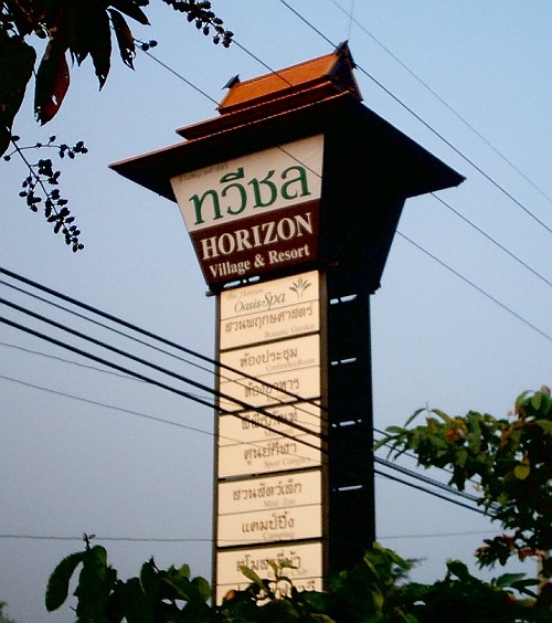 |
| Horizon Tower |
5. After 100 meters (300 ft), you will pass the entrance of HORIZON VILLAGE & RESORT (โรงแรม ฮอไรซัน วิลเลจ แอนด์ รีสอร์ท).
 |
| Horizon Village & Resort; the entrance is on the left in the photo → Google Street View |
Just a few meters after the entrance, adjacent to the highway, there is a car parking area in front of Coffee House (บ้านกาแฟ) (photo below).
 |
| Coffee House → Google Street View |
6. Continue, and 200 meters (0.1 mi) ahead, you will pass twin road signs, บ. น้ำแพร่ (Ban Nam Phrae) and บ. ป่าดู่ (Ban Pa Du) (in black Thai script on a white ground, the signs pointing to the right), and immediately thereafter you will cross a bridge over a small canal, คลองน้ำแพร่ (Klong Nam Phrae).
 |
| Twin road signs (Ban Nam Phrae, Ban Pa Du) on the left, the bridge further ahead → Google Street View |
The bridge itself isn't easy to spot, but it is always adorned with a large, colorful plaque honoring the royal family on the highway median strip.
 |
| The bridge is over a canal and with two underpasses parallel to the canal; the bridge is always adorned with a colorful plaque honoring the royal family → Google Street View |
Ban Nam Phrae is a village adjacent to the right (eastern) side of the highway next to that bridge. There is the Intersection Ban Nam Phrae where the country road underpasses the highway. If you don't know yet about this complex and confusing intersection with its two rather narrow underpasses parallel to Klong Nam Phrae, in no way should you take these underpasses when driving a car! It is strongly recommended to take the next U-turn of the highway when driving a car, but if you are an experienced motorcyclist, you may take that underpass instead of the U-turn, and, above all, if you are a bicyclist or pedestrian, taking the underpass carefully would be your best option.
7. There is a U-turn on the highway just 500 meters (0.3 mi) from the bridge at Ban Nam Phrae. This is the first U-turn after Horizon. Take this U-turn. — ที่กลับรถแรก
 |
| U-turn, indicated by the yellow traffic sign on the median strip of the highway → Google Street View |
8. So, after the U-turn, you are taking the highway in the opposite direction (towards Chiang Mai), but you need to exit the highway after only 500 meters (0.3 mi). Along these 500 meters, you will pass two road signs (the signs point to the left). The first road sign, บ. น้ำแพร่ (Ban Nam Phrae), was recently removed and may be reinstalled later. The second traffic sign, บ. ป่าดู่ (Ban Pa Du), is still present.
 |
| "Ban Nam Phrae" road sign (currently defunct) → Google Street View |
9. You have reached EXIT 'BAN NAM PHRAE' of Highway #118, where this exit becomes a country road on the left just before the bridge. Leave the highway here (turn left) and continue on the country road.
 |
| Exit "Ban Nam Phrae", just before the bridge → Google Street View |
10. Once you turn onto this country road, you will pass the village, Ban Nam Phrae, and 400 meters (0.3 mi) from the exit, the monastery, Wat Nam Phrae (วัดน้ำแพร่), will be on your right. Continue towards the next village, Ban Pa Du. — ทางออกถนนไหญ่ที่ บ. น้ำแพร่ไป บ. ป่าดู่
 |
| A monastery, Wat Nam Phrae → Google Street View |
11. Exactly 1.5 km (0.9 mi) from the Ban Nam Phrae exit, or 350 meters (0.2 mi) before the village center of Ban Pa Du, the country road comes to a sharp left curve with a T-junction of a subordinate road. Don't go straight onto the subordinate road! Follow the country road in the left direction!
 |
| A sharp left turn on the country road, with a T-junction of a minor road → Google Street View |
12. You will pass through the village center of Ban Pa Du. Only 180 meters (0.1 mi) after the village center, there is a junction, where the difficult-to-see main route turns right towards the village Ban Pa Lan, while the subordinate road goes straight towards Ban Pa Tio, and the left subordinate road is a new dead-end street.
 |
| A junction with a sharp right curve of the (main) country road, and a smaller (subordinate) road going straight → Google Street View |
Both directions, straight (subordinate road) and right (main country road), would lead you to Baan Sammi. Google Maps may offer you both routes through its navigation app. However, if you drive a car, it is recommended to follow the direction to the right at this junction, as this road is broader and less winding. — ผ่าน บ. ป่าดู่ ไปทาง บ. ป่าลาน — In case you choose the straight route, you will reach the next village, Ban Pa Tio (บ้านป่าติ้ว), after 1 km (0.6 mi), and before entering that village (one hundred meters before the monastery of Ban Pa Tio, Wat Pitayaram), you have to turn right into a narrow, winding village street, pass the village, and after the village, you will see Baan Sammi on your left.
13. If you have followed the (main) country road by turning right, just 150 meters (500 ft) from the junction, you will pass the monastery of Ban Pa Du which is on your right: WAT SI PRA DU.
 |
| A monastery, Wat Si Pra Du → Google Street View |
14. A few hundred meters from this monastery, you will approach the next village, Ban Pa Lan (บ. ป่าลาน), marked by a village sign in black Thai script on a white background (the sign is currently defunct). The village consists of loosely scattered houses, and when you pass the first group of houses in this village, you will see a tall white concrete water tower beyond a rice field on your left.
 |
| On your left, a tall white concrete water tower beyond a rice field → Google Street View |
15. Further ahead, and only 850 meters (0.5 mi) from the monastery of Ban Pa Du, you will see a small cremation area with a tall cremation tower on the left side of the road. The view of the tower could be obscured by trees and thus overlooked. Slow down!
 |
| Cremation area, with a tall cremation tower → Google Street View |
16. Just at the end of this cremation area, there is a T-junction, where a narrow, subordinate road divides from the country road. Turn left here. — เลี้ยวซ้ายสามแยกทางไปวัดป่าลาน
 |
| T-junction, just after the cremation area → Google Street View |
17. Only 140 meters (460 ft) from the junction, you will pass the monastery of Ban Pa Lan (วัดป่าลาน), which is on your right and is hidden by a tall Bodhi tree: WAT PA LAN.
 |
| A monastery, Wat Pa Lan → Google Street View |
18. Only a few meters after the monastery, you will reach a junction where the main route branches off to the left.
 |
| Junction ahead, turn left! → Google Street View |
Turn left, and a few meters after that junction, the main route takes a sharp right curve (→ Google Street View). Then the country road continues straight toward the next village, Ban Pa Yang Poi (บ. ป่ายางปอย).
19. Halfway to the village, Ban Pa Yang Poi, you will see a large, light gray new building (a vehicle body repair and paint shop) on the left.
 |
| A vehicle body repair and paint shop → Google Street View |
After the building, the road makes a slight S-curve. There you will see a wooden village sign for Ban Pa Yang Poi on the left unless it is overgrown with plants.
 |
| Wooden village sign of Ban Pa Yang Poi |
20. Follow the country road for a few hundred meters, and then you will reach the village, Ban Pa Yang Poi, previously hidden by trees (as shown in the photo), but most were cut in 2025.
 |
| Approaching the village Ban Pa Yang Poi hidden behind trees → Google Street View |
Just where the trees previously obscured the view, the country road makes a sharp right turn, with a side road joining from the left. Drive slowly; this T-junction is dangerous, and turn left onto the minor road!
 |
| The T-junction when entering Ban Pa Yang Poi → Google Street View |
21. Then go straight and after a few meters, you will see a second T-junction, which you will pass straight ahead, but drive more slowly! — เลี้ยวซ้ายสามแยก บ. ป่ายางปอย หนึ่ง้อยเมตรถึง บ้านแซมมี อยู่ข้างขวา
 |
| T-junction ahead, go straight, Baan Sammi is hidden behind the wooden fence by trees and bamboo → Google Street View |
22. On the right side, along the road and ditch, you will see the typical wooden fence of the Baan Sammi property with the main entrance gate (Gate 1). You have arrived at BAAN SAMMI. The second gate (Gate 2) further on looks somewhat different (not shown in the photo below) and should not be confused with the main gate.
 |
| The main entrance gate (gate 1) to the private driveway of Baan Sammi → Google Street View |
 |
| The main entrance gate (Gate 1) of Baan Sammi with its left and right sides (top left and right) The property of Baan Sammi Nature Retreat and Bambusetum: aerial view (bottom) |
On the right side of the main entrance gate (Gate 1), you will see the nameplate above the entrance door, and both the house number plate and the doorbell on the left side of the door. Please, park your car or motorbike off the road, just on the driveway in front of the entrance gate, ring the doorbell, open the door and enter, and walk to the office on the right side.
 |
| The entrance door of Baan Sammi, on the right side of the main entrance gate (Gate 1) |
For more details, see Chapter 9, Street View of Baan Sammi.